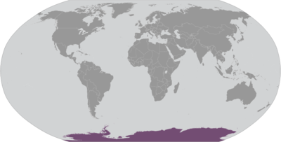
Country exposure · AQ
Antarctica
Antarctica · the Antarctic Treaty and its follow-on agreements govern the use of Antarctica, ensuring it is used only for peaceful purposes and scientific research; signed in 1959 and in force since 1961, the original Treaty bans military activity, weapons testing, and nuclear waste disposal, while allowing military personnel to assist with research or other peaceful efforts; it promotes international cooperation in science, guarantees the free exchange of research, and freezes territorial claims; the Treaty covers all land and ice south of 60° south latitude, and allows Treaty nations to inspect any station or facility decisions are made by consensus at annual meetings, and member countries implement these decisions through their national laws (see “Legal system”); additional agreements have strengthened the Treaty system, including conventions to protect seals (1972) and other marine life (1980), as well as an environmental protocol (1991, took effect in 1998); the protocol bans mining and includes strict rules on environmental impact, waste, pollution, wildlife, and protected areas; as of December 2024, there are 58 member nations : 29 consultative members , including the 7 claimant countries (Argentina, Australia, Chile, France, New Zealand, Norway, and the UK), and 29 non-consultative members ; a permanent Antarctic Treaty Secretariat, established in 2004 in Buenos Aires, supports the system
What Antarctica means for your money, the prices you pay, the tariffs in motion, and where U.S. policy could change both.
56
Population
U.S. exposure
Minimal direct economic exposure
Antarctica is not a significant U.S. goods-trade partner and has no tracked tariff actions. Policy changes here are unlikely to reach American prices directly.
Reference
The country itself
Antarctica · Geography, people, economy, and government, public-domain data from the CIA World Factbook.
Speculation over the existence of a "southern land" was confirmed in the early 1820s when British and American commercial operators and British and Russian national expeditions began exploring the Antarctic Peninsula region and other areas south of the Antarctic Circle. In 1840, it was finally established that Antarctica was indeed a continent and not merely a group of islands or an area of ocean. Several exploration "firsts" were achieved in the early 20th century, but the area saw little human activity. Following World War II, however, the continent experienced an upsurge in scientific research. A number of countries have set up a range of year-round and seasonal stations, camps, and refuges to support scientific research in Antarctica. Seven have made territorial claims, with two maintaining the basis for a claim, but most countries do not recognize these claims. In order to form a legal framework for countries' activities on the continent, an Antarctic Treaty was negotiated that neither denies nor recognizes existing territorial claims; it was signed in 1959 and entered into force in 1961. Also relevant to Antarctic governance are the Environmental Protocol to the Antarctic Treaty and the Convention on the Conservation of Antarctic Marine Living Resources.
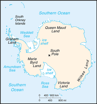
Geography
- Location
- continent mostly south of the Antarctic Circle
- Area
- 14.2 million sq km
- Climate
- the coldest, windiest, and driest continent on Earth; severe low temperatures vary with latitude, elevation, and distance from the ocean; East Antarctica is colder than West Antarctica because of its higher elevation; Antarctic Peninsula has the most moderate climate; higher temperatures occur in January along the coast and average slightly below freezing; summers characterized by continuous daylight, while winters bring continuous darkness; persistent high pressure over the interior brings dry, subsiding air that results in very little cloud cover
- Terrain
- about 99% thick continental ice sheet and 1% barren rock, with average elevations between 2,000 and 4,000 m; mountain ranges up to nearly 5,000 m; ice-free coastal areas include parts of southern Victoria Land, Wilkes Land, the Antarctic Peninsula area, and parts of Ross Island on McMurdo Sound; glaciers form ice shelves along about half of the coastline, and floating ice shelves constitute 11% of the area of the continent
- Natural resources
- iron ore, chromium, copper, gold, nickel, platinum and other minerals, and coal and hydrocarbons have been found in small noncommercial quantities; mineral exploitation except for scientific research is banned by the Environmental Protocol to the Antarctic Treaty; krill, icefish, toothfish, and crab have been taken by commercial fisheries, which are managed through the Commission for the Conservation of Antarctic Marine Living Resources (CCAMLR)
- Coastline
- 17,968 km
- Natural hazards
- katabatic (gravity-driven) winds blow coastward from the high interior; frequent blizzards form near the foot of the plateau; cyclonic storms form over the ocean and move clockwise along the coast; large icebergs may calve from ice shelf volcanism: volcanic activity on Deception Island and isolated areas of West Antarctica; other seismic activity rare and weak
People & society
- Population
- no permanent inhabitants, but staff is present at year-round and summer-only research stations note: 56 countries have signed the 1959 Antarctic Treaty; 30 of those operate a number of seasonal-only (summer) and year-round research stations on the continent and its nearby islands; the population varies from approximately 5,000 in summer to 1,100 in winter, with about 1,000 support personnel on ships nearby as of 2024, peak summer (December-February) maximum capacity in scientific stations - 4,713 total; Argentina 425, Australia 238, Belarus 15, Belgium 55, Brazil 64, Bulgaria 25, Chile 375, China 164, Czechia 32, Ecuador 35, Finland 16, France 136, France and Italy jointly 70, Germany 60, India 72, Italy 150, Japan 130, South Korea 158, New Zealand 85, Norway 60, Peru 30, Poland 41, Russia 211, South Africa 80, Spain 79, Sweden 16, Ukraine 15, United Kingdom 315, United States 1,495 , Uruguay 66 (2024) winter (June-August) maximum capacity in scientific stations - 1,056 total; Argentina 221, Australia 52, Brazil 15, Chile 114, China 32, France 24, France and Italy jointly 13, Germany 9, India 48, Japan 40, Netherlands 10, South Korea 25, NZ 11, Norway 7, Poland 16, Russia 125, South Africa 15, Ukraine 12, UK 44, US 215, Uruguay 8 (2024)
Government
- Government type
- the Antarctic Treaty and its follow-on agreements govern the use of Antarctica, ensuring it is used only for peaceful purposes and scientific research; signed in 1959 and in force since 1961, the original Treaty bans military activity, weapons testing, and nuclear waste disposal, while allowing military personnel to assist with research or other peaceful efforts; it promotes international cooperation in science, guarantees the free exchange of research, and freezes territorial claims; the Treaty covers all land and ice south of 60° south latitude, and allows Treaty nations to inspect any station or facility decisions are made by consensus at annual meetings, and member countries implement these decisions through their national laws (see “Legal system”); additional agreements have strengthened the Treaty system, including conventions to protect seals (1972) and other marine life (1980), as well as an environmental protocol (1991, took effect in 1998); the protocol bans mining and includes strict rules on environmental impact, waste, pollution, wildlife, and protected areas; as of December 2024, there are 58 member nations : 29 consultative members , including the 7 claimant countries (Argentina, Australia, Chile, France, New Zealand, Norway, and the UK), and 29 non-consultative members ; a permanent Antarctic Treaty Secretariat, established in 2004 in Buenos Aires, supports the system
Full reference data
Every field, by section, CIA World Factbook. Open a topic to expand it.