Country exposure · AS
American Samoa
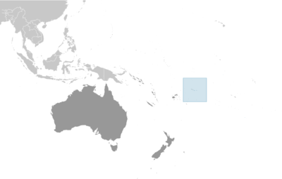
Australia Oceania · Pago Pago · unincorporated, unorganized Territory of the US with local self-government; republican form of territorial government with separate executive, legislative, and judicial branches
What American Samoa means for your money, the prices you pay, the tariffs in motion, and where U.S. policy could change both.
43K
Population
$871M
GDP
U.S. exposure
Minimal direct economic exposure
American Samoa is not a significant U.S. goods-trade partner and has no tracked tariff actions. Policy changes here are unlikely to reach American prices directly.
Reference
The country itself
Australia Oceania · Geography, people, economy, and government, public-domain data from the CIA World Factbook.
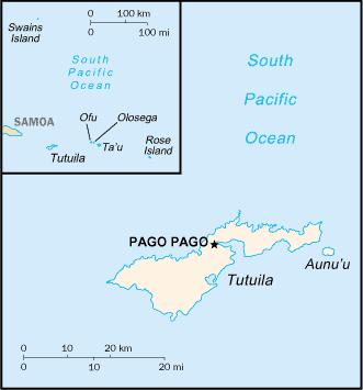
Tutuila -- the largest island in American Samoa -- was settled by 1000 B.C., and the island served as a refuge for exiled chiefs and defeated warriors from the other Samoan islands. The Manu’a Islands, which are also now part of American Samoa, developed a traditional chiefdom that maintained autonomy by controlling oceanic trade. In 1722, Dutch explorer Jacob ROGGEVEEN was the first European to sail through the Manu’a Islands, and he was followed by French explorer Louis Antoine DE BOUGAINVILLE in 1768. Whalers and missionaries arrived in American Samoa in the 1830s, but American and European traders tended to favor the port in Apia -- now in independent Samoa -- over the smaller and less-developed Pago Pago on Tutuila. In the mid-1800s, a dispute arose in Samoa over control of the Samoan archipelago, with different chiefs gaining support from Germany, the UK, and the US. In 1872, the high chief of Tutuila offered the US exclusive rights to Pago Pago in return for US protection, but the US rejected this offer. As fighting resumed, the US agreed to the chief’s request in 1878 and set up a coaling station at Pago Pago. In 1899, with continued disputes over succession, Germany and the US agreed to divide the Samoan islands, while the UK withdrew its claims in exchange for parts of the Solomon Islands. Local chiefs on Tutuila formally ceded their land to the US in 1900, followed by the chief of Manu’a in 1904. The territory was officially named “American Samoa” in 1911. The US administered the territory through the Department of the Navy. In 1949, there was an attempt to organize the territory, granting it formal self-government, but local chiefs helped defeat the measure in the US Congress. Administration was transferred to the Department of the Interior in 1951, and in 1967, American Samoa adopted a constitution that provides significant protections for traditional Samoan land-tenure rules, language, and culture. In 1977, after four attempts, voters approved a measure to directly elect their governor. Nevertheless, American Samoa officially remains an unorganized territory, and people born in American Samoa are US nationals rather than US citizens.
Geography
- Location
- Oceania, group of islands in the South Pacific Ocean, about halfway between Hawaii and New Zealand
- Area
- 224 sq km
- Climate
- tropical marine, moderated by southeast trade winds; annual rainfall averages about 3 m; rainy season (November to April), dry season (May to October); little seasonal temperature variation
- Terrain
- five volcanic islands with rugged peaks and limited coastal plains, two coral atolls (Rose Atoll, Swains Island)
- Natural resources
- pumice, pumicite
- Coastline
- 116 km
- Natural hazards
- cyclones common from December to March volcanism: limited volcanic activity on the Ofu and Olosega Islands; neither has erupted since the 19th century
People & society
- Population
- 43,268 (2025 est.)
- Nationality
- American Samoan(s) (US nationals)
- Ethnic groups
- Pacific Islander 88.7% (includes Samoan 83.2%, Tongan 2.2%, other 3.3%), Asian 5.8% (includes Filipino 3.4%, other 2.4%), mixed 4.4%, other 1.1% (2020 est.)
- Languages
- Samoan 87.9% (closely related to Hawaiian and other Polynesian languages), English 3.3%, Tongan 2.1%, other Pacific Islander 4.1%, Asian languages 2.1%, other 0.5% (2020 est.)
- Religions
- Christian 98.3%, other <1%, unaffiliated <1% (2020 est.)
- Median age
- 30.6 years (2025 est.)
- Life expectancy at birth
- 75.8 years (2024 est.)
Economy
- Economic overview
- tourism, tuna, and government services-based territorial economy; sustained economic decline; vulnerable tuna canning industry; large territorial government presence; minimum wage increases to rise to federal standards by 2036
- Industries
- tuna canneries (largely supplied by foreign fishing vessels), handicrafts
- Agricultural products
- bananas, coconuts, vegetables, taro, breadfruit, yams, copra, pineapples, papayas; dairy products, livestock
- Exports - partners
- Australia 31%, UK 18%, Tanzania 9%, UAE 7%, Senegal 6% (2023)
- Imports - partners
- Singapore 28%, NZ 15%, Fiji 14%, Taiwan 11%, Malaysia 11% (2023)
Government
- Government type
- unincorporated, unorganized Territory of the US with local self-government; republican form of territorial government with separate executive, legislative, and judicial branches
- Capital
- Pago Pago
- Independence
- none (territory of the US)
- Constitution
- adopted 17 October 1960; revised 1 July 1967
- Executive branch
- President Donald J. TRUMP (since 20 January 2025)
- Legislative branch
- note: American Samoa elects 1 member by simple majority popular vote to serve a 2-year term as a delegate to the US House of Representatives; the delegate can vote when serving on a committee and when the House meets as the Committee of the Whole House, but not when legislation is submitted for a “full floor” House vote
Full reference data
Every field, by section, CIA World Factbook. Open a topic to expand it.
Introduction
Travel Facts
Please visit the following links to find further information about your desired destination.
CDC - To learn what vaccines and health precautions to take while visiting your destination.
US State Dept Travel Information - Overall information about foreign travel for US citizens.
To obtain an international driving permit (IDP). Only two organizations in the US issue IDPs: American Automobile Association (AAA) and American Automobile Touring Alliance (AATA)
How to get help in an emergency? Contact the nearest US embassy or consulate, or call one of these numbers: from the US or Canada - 1-888-407-4747 or from Overseas - +1 202-501-4444
Page last updated: Wednesday, June 19, 2024