Country exposure · CX
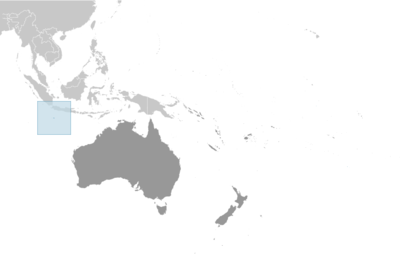
Christmas Island (in the Indian Ocean)
Australia Oceania · The Settlement (Flying Fish Cove) · non-self-governing overseas territory of Australia
What Christmas Island (in the Indian Ocean) means for your money, the prices you pay, the tariffs in motion, and where U.S. policy could change both.
$68K
U.S. imports, 2025
-96.1%
change in one year
$632K
U.S. exports, 2025
2K
Population
In your house
What you buy that Christmas Island (in the Indian Ocean) makes
America bought $68K in goods from Christmas Island (in the Indian Ocean) in 2025, down 96.1% in a single year. Of every $100 of it, here's where the money went.
Electric apparatus
Minimum value shipments
Industrial machines, other
Photo, service industry machinery
Industrial engines
Excavating machinery
Other (movies, miscellaneous imports, and special transactions)
2026 so far (through May): $16K in imports. Source: U.S. Census Bureau, International Trade in Goods (customs basis).
The other direction
What America sells to Christmas Island (in the Indian Ocean)
$632K in 2025, a trade rupture cuts both ways, for American producers as well as American prices.
Generators, accessories
$163KMeasuring, testing, control instruments
$98KSynthetic rubber-primary
$63KPulpwood and woodpulp
$60KAluminum and alumina
$36KPhoto, service industry machinery
$30KMinimum value shipments
$29KCopper
$28KElectric apparatus
$24KWhere you stand
U.S. tariff posture toward Christmas Island (in the Indian Ocean)
No U.S. tariff action singles this country out. Its goods face the universal 10% temporary import surcharge under Section 122 of the Trade Act (which replaced the IEEPA reciprocal baseline in February 2026) plus the sectoral Section 232 duties — steel and aluminum at 50% — that apply to all countries. The Section 122 surcharge is statutorily temporary — scheduled to lapse on or about July 23, 2026 (a 150-day cap) unless extended or replaced.
Reciprocal tariff (universal baseline)
10%
The universal 10% floor, a Section 122 import surcharge since February 2026, previously the EO 14257 reciprocal baseline, applies to nearly all U.S. imports. This country has no higher assigned rate of its own.
Policy in motion
Tariff status: a moving target
No U.S. tariff action names Christmas Island (in the Indian Ocean). These are the universal measures, applied to every country without a country-specific arrangement, that set its treatment.
2026-04-06
Section 232 metals coverage expanded
In effectThe April 2026 proclamation strengthening Section 232 actions on aluminum, steel, and copper expanded derivative-product coverage for all countries, keeping the general metals rate at 50%.
91 FR 18201 →2026-02-24
IEEPA reciprocal tariffs terminated — replaced by 10% Section 122 surcharge
In effectExecutive Order 14389 (Ending Certain Tariff Actions) terminated the IEEPA tariff duties — including the EO 14257 reciprocal baseline — effective February 24, 2026. A flat 10% Section 122 temporary import surcharge (Proclamation 11012 of February 20, 2026) replaced them, leaving the universal rate unchanged at 10% on a different statutory basis. Section 122 caps such surcharges at 150 days, so this 10% surcharge is scheduled to lapse on or about July 23, 2026 absent further action (the administration has signaled it could raise the rate toward the 15% statutory maximum).
91 FR 9437 →2025-11-13
Agricultural products exempted from reciprocal tariffs
In effectExecutive Order 14360 of November 14, 2025 removed reciprocal duties from certain agricultural products listed in its annexes (coffee, cocoa, bananas, and other goods the U.S. does not produce in sufficient quantity), retroactive to November 13, 2025 — for all countries subject to the reciprocal tariff.
90 FR 54091 →2025-06-04
Section 232 steel and aluminum duties doubled to 50%
In effectThe June 3, 2025 proclamation raised Section 232 duties on steel and aluminum articles and derivatives from 25% to 50% for all countries, effective June 4, 2025.
90 FR 24199 →2025-04-05
Universal 10% reciprocal baseline takes effect
In effectExecutive Order 14257 (signed April 2, 2025) imposed a 10% ad valorem reciprocal duty on imports from all trading partners, effective April 5, 2025. Countries without a higher Annex I rate remain at this baseline.
Federal Register · 2025-06063 →2025-03-12
Section 232 steel and aluminum duties set at 25% for all countries
In effectProclamations of February 10, 2025 terminated all country exemptions and quota arrangements and applied 25% Section 232 duties to steel and aluminum imports from every country, effective March 12, 2025.
90 FR 9817 →
Reference
The country itself
Australia Oceania · Geography, people, economy, and government, public-domain data from the CIA World Factbook.
Although Europeans sighted Christmas Island in 1615, it was named for the day of its rediscovery in 1643. Steep cliffs and dense jungle hampered attempts to explore the island over the next two centuries. The discovery of phosphate on the island in 1887 led to the UK annexing it the following year. In 1898, 200 Chinese indentured servants were brought in to work the mines, along with Malays, Sikhs, and a small number of Europeans. The UK administered Christmas Island from Singapore. Japan invaded the island in 1942, but islanders sabotaged Japanese mining operations, making the mines relatively unproductive. After World War II, Australia and New Zealand bought the company mining the phosphate, and in 1958, the UK transferred sovereignty from Singapore to Australia in exchange for $20 million to compensate for the loss of future phosphate income. In 1980, Australia set up the Christmas Island National Park and expanded its boundaries throughout the 1980s until it covered more than 60% of the island’s territory. The phosphate mine was closed in 1987 because of environmental concerns, and Australia has rejected several efforts to reopen it. In the 1980s, boats of asylum seekers started landing on Christmas Island, and the migrants claimed refugee status because they were on Australian territory. In 2001, Australia declared Christmas Island to be outside the Australian migration zone and built an immigration detention center on the island. Completed in 2008, the controversial detention center was closed in 2018 but then reopened in 2019. In 2020, the center served as a coronavirus quarantine facility for Australian citizens evacuated from China.
Geography
- Location
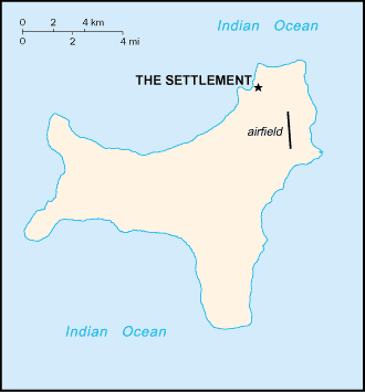
- Southeastern Asia, island in the Indian Ocean, south of Indonesia
- Area
- 135 sq km
- Climate
- tropical with a wet season (December to April) and dry season; heat and humidity moderated by trade winds
- Terrain
- steep cliffs along coast rise abruptly to central plateau
- Natural resources
- phosphate, beaches
- Coastline
- 138.9 km
- Natural hazards
- the narrow fringing reef surrounding the island can be a maritime hazard
People & society
- Population
- 1,692 (2021 est.)
- Nationality
- Christmas Islander(s)
- Ethnic groups
- Chinese 70%, European 20%, Malay 10% (2001)
- Languages
- English (official) 27.6%, Mandarin 17.2%, Malay 17.1%, Cantonese 3.9%, Min Nan 1.6%, Tagalog 1%, other 4.5%, unspecified 27.1% (2016 est.)
- Religions
- Muslim 19.4%, Buddhist 18.3%, Roman Catholic 8.8%, Protestant 6.5% (includes Anglican 3.6%, Uniting Church 1.2%, other 1.7%), other Christian 3.3%, other 0.6%, none 15.3%, unspecified 27.7% (2016 est.)
- Median age
- 38 years (2021 est.)
Economy
- Economic overview
- high-income Australian territorial economy; development through government services and phosphate mining; operates Australia’s Immigration Detention Centre; increasing tourism and government investments; sustained environmental protections
- Industries
- tourism, phosphate extraction (near depletion)
- Exports - partners
- Indonesia 30%, USA 26%, Malaysia 12%, Ireland 8%, UK 7% (2023)
- Imports - partners
- USA 58%, Australia 40%, Malaysia 1%, Fiji 0%, Singapore 0% (2023)
Government
- Government type
- non-self-governing overseas territory of Australia
- Capital
- The Settlement (Flying Fish Cove)
- Independence
- none (territory of Australia)
- Constitution
- 1 October 1958 (Christmas Island Act 1958)
- Executive branch
- King CHARLES III (since 8 September 2022); represented by Governor-General of the Commonwealth of Australia General Sam MOSTYN (since 1 July 2024)
- Legislative branch
- Christmas Island Shire Council
Full reference data
Every field, by section, CIA World Factbook. Open a topic to expand it.