Country exposure · EH
Western Sahara
Africa · UTC 0 (5 hours ahead of Washington, DC, during Standard Time) · legal status of territory and issue of sovereignty unresolved; territory contested by Morocco and Polisario Front (Popular Front for the Liberation of the Saguia el Hamra and Rio de Oro), which in February 1976 formally proclaimed a government-in-exile of the Sahrawi Arab Democratic Republic (SADR), near Tindouf, Algeria, led by President Mohamed ABDELAZIZ until his death in May 2016; current President Brahim GHALI elected in July 2016; territory partitioned between Morocco and Mauritania in April 1976 when Spain withdrew, with Morocco acquiring northern two-thirds; Mauritania, under pressure from Polisario guerrillas, abandoned all claims to its portion in August 1979; Morocco moved to occupy that sector shortly thereafter and has since asserted administrative control; the Polisario's government-in-exile was seated as an Organization of African Unity (OAU) member in 1984; Morocco between 1980 and 1987 built a fortified sand berm delineating the roughly 75% of Western Sahara west of the barrier that currently is controlled by Morocco; guerrilla activities continued sporadically until a UN-monitored cease-fire was implemented on 6 September 1991 (Security Council Resolution 690) by the United Nations Mission for the Referendum in Western Sahara (MINURSO)
What Western Sahara means for your money, the prices you pay, the tariffs in motion, and where U.S. policy could change both.
652K
Population
Where you stand
U.S. tariff posture toward Western Sahara
No U.S. tariff action singles this country out. Its goods face the universal 10% temporary import surcharge under Section 122 of the Trade Act (which replaced the IEEPA reciprocal baseline in February 2026) plus the sectoral Section 232 duties — steel and aluminum at 50% — that apply to all countries. The Section 122 surcharge is statutorily temporary — scheduled to lapse on or about July 23, 2026 (a 150-day cap) unless extended or replaced.
Reciprocal tariff (universal baseline)
10%
The universal 10% floor, a Section 122 import surcharge since February 2026, previously the EO 14257 reciprocal baseline, applies to nearly all U.S. imports. This country has no higher assigned rate of its own.
Policy in motion
Tariff status: a moving target
No U.S. tariff action names Western Sahara. These are the universal measures, applied to every country without a country-specific arrangement, that set its treatment.
2026-04-06
Section 232 metals coverage expanded
In effectThe April 2026 proclamation strengthening Section 232 actions on aluminum, steel, and copper expanded derivative-product coverage for all countries, keeping the general metals rate at 50%.
91 FR 18201 →2026-02-24
IEEPA reciprocal tariffs terminated — replaced by 10% Section 122 surcharge
In effectExecutive Order 14389 (Ending Certain Tariff Actions) terminated the IEEPA tariff duties — including the EO 14257 reciprocal baseline — effective February 24, 2026. A flat 10% Section 122 temporary import surcharge (Proclamation 11012 of February 20, 2026) replaced them, leaving the universal rate unchanged at 10% on a different statutory basis. Section 122 caps such surcharges at 150 days, so this 10% surcharge is scheduled to lapse on or about July 23, 2026 absent further action (the administration has signaled it could raise the rate toward the 15% statutory maximum).
91 FR 9437 →2025-11-13
Agricultural products exempted from reciprocal tariffs
In effectExecutive Order 14360 of November 14, 2025 removed reciprocal duties from certain agricultural products listed in its annexes (coffee, cocoa, bananas, and other goods the U.S. does not produce in sufficient quantity), retroactive to November 13, 2025 — for all countries subject to the reciprocal tariff.
90 FR 54091 →2025-06-04
Section 232 steel and aluminum duties doubled to 50%
In effectThe June 3, 2025 proclamation raised Section 232 duties on steel and aluminum articles and derivatives from 25% to 50% for all countries, effective June 4, 2025.
90 FR 24199 →2025-04-05
Universal 10% reciprocal baseline takes effect
In effectExecutive Order 14257 (signed April 2, 2025) imposed a 10% ad valorem reciprocal duty on imports from all trading partners, effective April 5, 2025. Countries without a higher Annex I rate remain at this baseline.
Federal Register · 2025-06063 →2025-03-12
Section 232 steel and aluminum duties set at 25% for all countries
In effectProclamations of February 10, 2025 terminated all country exemptions and quota arrangements and applied 25% Section 232 duties to steel and aluminum imports from every country, effective March 12, 2025.
90 FR 9817 →
Go deeper
The supply chain view
Western Sahara sits upstream of 1 essential American goods through 1 tracked inputs.
Full supply-map profile →Reference
The country itself
Africa · Geography, people, economy, and government, public-domain data from the CIA World Factbook.
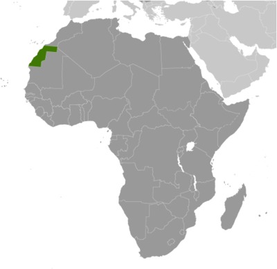
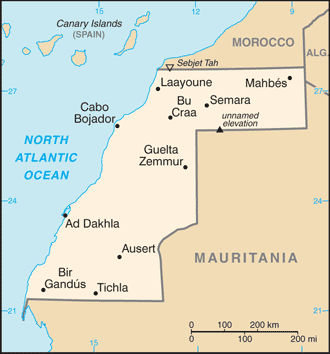
Western Sahara is a non-self-governing territory on the northwest coast of Africa bordered by Morocco, Mauritania, and Algeria. After Spain withdrew from its former colony of Spanish Sahara in 1976, Morocco annexed the northern two-thirds of Western Sahara and claimed the rest of the territory in 1979, following Mauritania's withdrawal. A guerrilla war with the Polisario Front contesting Morocco's sovereignty ended in a 1991 cease-fire and the establishment of a UN peacekeeping operation. As part of this effort, the UN sought to offer a choice to the peoples of Western Sahara between independence (favored by the Polisario Front) or integration into Morocco. A proposed referendum on the question of independence never took place due to lack of agreement on voter eligibility. The approximately 1,600 km- (almost 1,000 mi-) long defensive sand berm, built by the Moroccans from 1980 to 1987 and running the length of the territory, continues to separate the opposing forces, with Morocco controlling the roughly three-quarters of the territory west of the berm. There are periodic ethnic tensions between the native Sahrawi population and Moroccan immigrants. Morocco maintains a heavy security presence in the territory. The UN revived direct talks about the territory between Morocco, the Polisario Front, Algeria, and Mauritania in December 2018.
Geography
- Location
- Northern Africa, bordering the North Atlantic Ocean, between Mauritania and Morocco
- Area
- 266,000 sq km
- Climate
- hot, dry desert; rain is rare; cold offshore air currents produce fog and heavy dew
- Terrain
- mostly low, flat desert with large areas of rocky or sandy surfaces rising to small mountains in south and northeast
- Natural resources
- phosphates, iron ore
- Coastline
- 1,110 km
- Natural hazards
- hot, dry, dust/sand-laden sirocco wind can occur during winter and spring; widespread harmattan haze exists 60% of time, often severely restricting visibility
People & society
- Population
- 652,271 (July 2020 est.)
- Nationality
- Sahrawi(s), Sahraoui(s)
- Ethnic groups
- Arab, Berber
- Languages
- Standard Arabic, Hassaniya Arabic, Moroccan Arabic, Berber, Spanish, French
- Religions
- Muslim
- Median age
- 21.8 years
- Life expectancy at birth
- 64.5 years
Economy
- Economic overview
- Western Sahara has a small market-based economy whose main industries are fishing, phosphate mining, tourism, and pastoral nomadism. The territory's arid desert climate makes sedentary agriculture difficult, and much of its food is imported. The Moroccan Government administers Western Sahara's economy and is a key source of employment, infrastructure development, and social spending in the territory. ++ Western Sahara's unresolved legal status makes the exploitation of its natural resources a contentious issue between Morocco and the Polisario. Morocco and the EU in December 2013 finalized a four-year agreement allowing European vessels to fish off the coast of Morocco, including disputed waters off the coast of Western Sahara. As of April 2018, Moroccan and EU authorities were negotiating an amendment to renew the agreement. ++ Oil has never been found in Western Sahara in commercially significant quantities, but Morocco and the Polisario have quarreled over rights to authorize and benefit from oil exploration in the territory. Western Sahara's main long-term economic challenge is the development of a more diverse set of industries capable of providing greater employment and income to the territory. However, following King MOHAMMED VI's November 2015 visit to Western Sahara, the Government of Morocco announced a series of investments aimed at spurring economic activity in the region, while the General Confederation of Moroccan Enterprises announced a $609 million investment initiative in the region in March 2015.
- Industries
- phosphate mining, handicrafts
Government
- Government type
- legal status of territory and issue of sovereignty unresolved; territory contested by Morocco and Polisario Front (Popular Front for the Liberation of the Saguia el Hamra and Rio de Oro), which in February 1976 formally proclaimed a government-in-exile of the Sahrawi Arab Democratic Republic (SADR), near Tindouf, Algeria, led by President Mohamed ABDELAZIZ until his death in May 2016; current President Brahim GHALI elected in July 2016; territory partitioned between Morocco and Mauritania in April 1976 when Spain withdrew, with Morocco acquiring northern two-thirds; Mauritania, under pressure from Polisario guerrillas, abandoned all claims to its portion in August 1979; Morocco moved to occupy that sector shortly thereafter and has since asserted administrative control; the Polisario's government-in-exile was seated as an Organization of African Unity (OAU) member in 1984; Morocco between 1980 and 1987 built a fortified sand berm delineating the roughly 75% of Western Sahara west of the barrier that currently is controlled by Morocco; guerrilla activities continued sporadically until a UN-monitored cease-fire was implemented on 6 September 1991 (Security Council Resolution 690) by the United Nations Mission for the Referendum in Western Sahara (MINURSO)
- Capital
- UTC 0 (5 hours ahead of Washington, DC, during Standard Time)
- Executive branch
- none
Full reference data
Every field, by section, CIA World Factbook. Open a topic to expand it.