Country exposure · GEC-SV
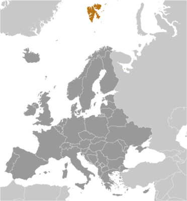
Svalbard (sometimes referred to as Spitsbergen, the largest island in the archipelago)
Europe · Longyearbyen · non-self-governing territory of Norway
What Svalbard (sometimes referred to as Spitsbergen, the largest island in the archipelago) means for your money, the prices you pay, the tariffs in motion, and where U.S. policy could change both.
3K
Population
U.S. exposure
Minimal direct economic exposure
Svalbard (sometimes referred to as Spitsbergen, the largest island in the archipelago) is not a significant U.S. goods-trade partner and has no tracked tariff actions. Policy changes here are unlikely to reach American prices directly.
Reference
The country itself
Europe · Geography, people, economy, and government, public-domain data from the CIA World Factbook.
Norse explorers may have first discovered the Svalbard archipelago in the 12th century. The islands served as an international whaling base during the 17th and 18th centuries. Norway's sovereignty was internationally recognized by treaty in 1920, and five years later Norway officially took over the territory. Coal mining started in the 20th century, and a Norwegian company and a Russian company are still in operation today. Travel between the settlements is accomplished with snowmobiles, aircraft, and boats.
Geography
- Location
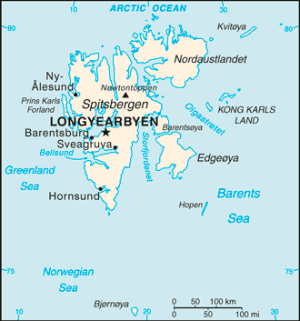
- Northern Europe, islands between the Arctic Ocean, Barents Sea, Greenland Sea, and Norwegian Sea, north of Norway
- Area
- 62,045 sq km
- Climate
- arctic, tempered by warm North Atlantic Current; cool summers, cold winters; North Atlantic Current flows along west and north coasts of Spitsbergen, keeping water open and navigable most of the year
- Terrain
- rugged mountains; much of the upland areas are ice covered; west coast clear of ice about half the year; fjords along west and north coasts
- Natural resources
- coal, iron ore, copper, zinc, phosphate, wildlife, fish
- Coastline
- 3,587 km
- Natural hazards
- ice floes often block the entrance to Bellsund (a transit point for coal export) on the west coast and occasionally make parts of the northeastern coast inaccessible to maritime traffic
People & society
- Population
- 2,556 (2025 est.)
- Ethnic groups
- Norwegian 61.1%, foreign population 38.9% (consists primarily of Russians, Thais, Swedes, Filipinos, and Ukrainians) (2021 est.)
- Languages
- Norwegian, Russian
Economy
- Economic overview
- high-income Norwegian island economy; major coal mining, tourism, and research sectors; recently established northernmost brewery; key whaling and fishing base; home to the Global Seed Vault
Government
- Government type
- non-self-governing territory of Norway
- Capital
- Longyearbyen
- Independence
- none (territory of Norway)
- Executive branch
- King HARALD V of Norway (since 17 January 1991)
- Legislative branch
- note: the Council acts much like a Norwegian municipality, with responsibility for infrastructure and utilities (including power, land-use and community planning, education, and child welfare); however, the state provides healthcare services
Full reference data
Every field, by section, CIA World Factbook. Open a topic to expand it.