Country exposure · GU
Guam
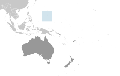
Australia Oceania · Hagatna (Agana) · unincorporated organized territory of the US with local self-government; republican form of territorial government with separate executive, legislative, and judicial branches
What Guam means for your money, the prices you pay, the tariffs in motion, and where U.S. policy could change both.
170K
Population
$6.9B
GDP
U.S. exposure
Minimal direct economic exposure
Guam is not a significant U.S. goods-trade partner and has no tracked tariff actions. Policy changes here are unlikely to reach American prices directly.
Reference
The country itself
Australia Oceania · Geography, people, economy, and government, public-domain data from the CIA World Factbook.
Guam was settled by Austronesian people around 1500 B.C. These people became the indigenous Chamorro and were influenced by later migrations, including the Micronesians in the first millennium A.D., and island Southeast Asians around 900. Society was stratified, with higher classes living along the coast and lower classes living inland. Spanish explorer Ferdinand MAGELLAN was the first European to see Guam in 1521, and Spain claimed the island in 1565 because it served as a refueling stop for ships between Mexico and the Philippines. Spain formally colonized Guam in 1668. Spain’s brutal repression of the Chamorro, along with new diseases and intermittent warfare, reduced the indigenous population from more than 100,000 to less than 5,000 by the 1700s. Spain tried to repopulate the island by forcing people from nearby islands to settle on Guam and preventing them from escaping. Guam became a hub for whalers and traders in the western Pacific in the early 1800s. During the 1898 Spanish-American War, the US Navy occupied Guam and set up a military administration. The US Navy opposed local control of government despite repeated petitions from the Chamorro. Japan invaded Guam in 1941 and instituted a repressive regime. During the US recapture of Guam in 1944, the island’s two largest villages were destroyed. After World War II, political pressure from local Chamorro leaders led to Guam being established as an unincorporated organized US territory in 1950, with US citizenship granted to all Chamorro. In a referendum in 1982, more than 75% of voters chose closer relations with the US over independence, although no change in status was made because of disagreements on the future right of Chamorro self-determination. The US military holds about 29% of Guam’s land and stations several thousand troops on the island. The installations are some of the most strategically important US bases in the Pacific; they also constitute the island’s most important source of income and economic stability.
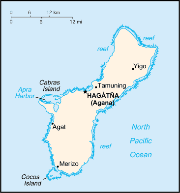
Geography
- Location
- Oceania, island in the North Pacific Ocean, about three-quarters of the way from Hawaii to the Philippines
- Area
- 544 sq km
- Climate
- tropical marine; generally warm and humid, moderated by northeast trade winds; dry season (January to June), rainy season (July to December); little seasonal temperature variation
- Terrain
- volcanic origin, surrounded by coral reefs; relatively flat coralline limestone plateau (source of most fresh water), with steep coastal cliffs and narrow coastal plains in north, low hills in center, mountains in south
- Natural resources
- aquatic wildlife (supporting tourism), fishing (largely undeveloped)
- Coastline
- 125.5 km
- Natural hazards
- frequent squalls during rainy season; relatively rare but potentially destructive typhoons (June to December)
People & society
- Population
- 169,532 (2024 est.)
- Nationality
- Guamanian(s) (US citizens)
- Ethnic groups
- Native Hawaiian and other Pacific Islander 46.1% (Chamorro 32.8%, Chuukese 6.7%, Palauan 1.4%, Pohnpeian 1.4%, Yapese 1%, other Native Hawaiian and other Pacific Islander 2.8%), Asian 35.5% (Filipino 29.1%, Korean 2.2%, Japanese 1.4%, Chinese (except Taiwanese) 1.3%, other Asian 1.5%), White 6.8%, African descent or African-American 0.9%, Indigenous 0.1%, other 0.6%, mixed 10% (2020 est.)
- Languages
- English 43.3%, Filipino 24.9%, Chamorro 16%, other Pacific Island languages 9.4%, Asian languages 6.5% (2020 est.)
- Religions
- Christian (predominantly Roman Catholic) 94.2%, folk religions 1.5%, Buddhist 1.1%, other 1.6%, unaffiliated 1.7% (2020 est.)
- Median age
- 30.5 years (2025 est.)
- Life expectancy at birth
- 78 years (2024 est.)
Economy
- Economic overview
- small Pacific island US territorial economy; upper income, tourism-based economy; hard-hit by COVID-19 disruptions; relaunched many industries via vaccination tourism; domestic economy relies on multiple military bases; environmentally fragile economy
- Industries
- national defense, tourism, construction, transshipment services, concrete products, printing and publishing, food processing, textiles
- Agricultural products
- fruits, copra, vegetables; eggs, pork, poultry, beef
- Exports - partners
- Taiwan 42%, Hong Kong 12%, Philippines 11%, Italy 8%, Australia 6% (2023)
- Imports - partners
- Singapore 52%, Japan 15%, Malaysia 6%, Taiwan 4%, Greece 4% (2023)
Government
- Government type
- unincorporated organized territory of the US with local self-government; republican form of territorial government with separate executive, legislative, and judicial branches
- Capital
- Hagatna (Agana)
- Independence
- none (territory of the US)
- Constitution
- effective 1 July 1950 (Guam Act of 1950 serves as a constitution)
- Executive branch
- President Donald J. TRUMP (since 20 January 2025)
- Legislative branch
- Legislature of Guam (Liheslaturan Guahan)
Full reference data
Every field, by section, CIA World Factbook. Open a topic to expand it.
Introduction
Travel Facts
Please visit the following links to find further information about your desired destination.
World Health Organization (WHO) - To learn what vaccines and health precautions to take while visiting your destination.
US State Dept Travel Information - Overall information about foreign travel for US citizens.
To obtain an international driving permit (IDP). Only two organizations in the US issue IDPs: American Automobile Association (AAA) and American Automobile Touring Alliance (AATA)
How to get help in an emergency? Contact the nearest US embassy or consulate, or call one of these numbers: from the US or Canada - 1-888-407-4747 or from Overseas - +1 202-501-4444
Page last updated: Monday, June 20, 2022