Country exposure · IO
British Indian Ocean Territory
South Asia · administered from London; often regarded as being on Diego Garcia
What British Indian Ocean Territory means for your money, the prices you pay, the tariffs in motion, and where U.S. policy could change both.
$6K
U.S. imports, 2025
-98.8%
change in one year
$13M
U.S. exports, 2025
In your house
What you buy that British Indian Ocean Territory makes
America bought $6K in goods from British Indian Ocean Territory in 2025, down 98.8% in a single year. Of every $100 of it, here's where the money went.
Minimum value shipments
Jewelry
jewelry
2026 so far (through May): $1K in imports. Source: U.S. Census Bureau, International Trade in Goods (customs basis).
The other direction
What America sells to British Indian Ocean Territory
$13M in 2025, a trade rupture cuts both ways, for American producers as well as American prices.
Metallurgical grade coal
$8MMedicinal equipment
$768Kmedical devices and equipment
Generators, accessories
$616KOther consumer nondurables
$544KLaboratory testing instruments
$496KMinimum value shipments
$367KChemicals-other
$263KVegetables
$261KAgriculture-manufactured, other
$189KWhere you stand
U.S. tariff posture toward British Indian Ocean Territory
No U.S. tariff action singles this country out. Its goods face the universal 10% temporary import surcharge under Section 122 of the Trade Act (which replaced the IEEPA reciprocal baseline in February 2026) plus the sectoral Section 232 duties — steel and aluminum at 50% — that apply to all countries. The Section 122 surcharge is statutorily temporary — scheduled to lapse on or about July 23, 2026 (a 150-day cap) unless extended or replaced.
Reciprocal tariff (universal baseline)
10%
The universal 10% floor, a Section 122 import surcharge since February 2026, previously the EO 14257 reciprocal baseline, applies to nearly all U.S. imports. This country has no higher assigned rate of its own.
Policy in motion
Tariff status: a moving target
No U.S. tariff action names British Indian Ocean Territory. These are the universal measures, applied to every country without a country-specific arrangement, that set its treatment.
2026-04-06
Section 232 metals coverage expanded
In effectThe April 2026 proclamation strengthening Section 232 actions on aluminum, steel, and copper expanded derivative-product coverage for all countries, keeping the general metals rate at 50%.
91 FR 18201 →2026-02-24
IEEPA reciprocal tariffs terminated — replaced by 10% Section 122 surcharge
In effectExecutive Order 14389 (Ending Certain Tariff Actions) terminated the IEEPA tariff duties — including the EO 14257 reciprocal baseline — effective February 24, 2026. A flat 10% Section 122 temporary import surcharge (Proclamation 11012 of February 20, 2026) replaced them, leaving the universal rate unchanged at 10% on a different statutory basis. Section 122 caps such surcharges at 150 days, so this 10% surcharge is scheduled to lapse on or about July 23, 2026 absent further action (the administration has signaled it could raise the rate toward the 15% statutory maximum).
91 FR 9437 →2025-11-13
Agricultural products exempted from reciprocal tariffs
In effectExecutive Order 14360 of November 14, 2025 removed reciprocal duties from certain agricultural products listed in its annexes (coffee, cocoa, bananas, and other goods the U.S. does not produce in sufficient quantity), retroactive to November 13, 2025 — for all countries subject to the reciprocal tariff.
90 FR 54091 →2025-06-04
Section 232 steel and aluminum duties doubled to 50%
In effectThe June 3, 2025 proclamation raised Section 232 duties on steel and aluminum articles and derivatives from 25% to 50% for all countries, effective June 4, 2025.
90 FR 24199 →2025-04-05
Universal 10% reciprocal baseline takes effect
In effectExecutive Order 14257 (signed April 2, 2025) imposed a 10% ad valorem reciprocal duty on imports from all trading partners, effective April 5, 2025. Countries without a higher Annex I rate remain at this baseline.
Federal Register · 2025-06063 →2025-03-12
Section 232 steel and aluminum duties set at 25% for all countries
In effectProclamations of February 10, 2025 terminated all country exemptions and quota arrangements and applied 25% Section 232 duties to steel and aluminum imports from every country, effective March 12, 2025.
90 FR 9817 →
Reference
The country itself
South Asia · Geography, people, economy, and government, public-domain data from the CIA World Factbook.
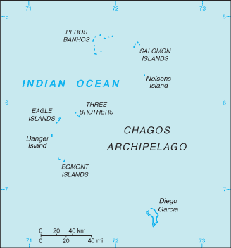
Formerly administered as part of the British Crown Colony of Mauritius, the British Indian Ocean Territory (BIOT) was established as an overseas territory of the UK in 1965. A number of the islands in the territory were later transferred to the Seychelles when it gained independence in 1976. Subsequently, BIOT has consisted of the six main island groups that make up the Chagos Archipelago. Only Diego Garcia, the largest and most southerly of the islands, is inhabited. It contains a joint UK-US naval support facility and hosts one of four dedicated ground antennas that assist in the operation of the Global Positioning System (GPS) navigation system -- the others are on Kwajalein (Marshall Islands); at Cape Canaveral, Florida (US); and on Ascension Island (Saint Helena, Ascension, and Tristan da Cunha). The US Air Force also operates a telescope array on Diego Garcia as part of the Ground-Based Electro-Optical Deep Space Surveillance System (GEODSS) for tracking orbital debris, which can be a hazard to spacecraft and astronauts. Between 1967 and 1973, the former agricultural workers who lived on the islands were relocated, primarily to Mauritius but also to the Seychelles. Negotiations with the UK between 1971 and 1982 resulted in the establishment of a trust fund to compensate the displaced islanders, known as Chagossians. Beginning in 1998, the islanders pursued a series of lawsuits against the British Government, seeking further compensation and the right to return to the territory. British court rulings in 2006 and 2007 invalidated immigration policies that had excluded the islanders from the archipelago, but in 2008, the House of Lords -- the final court of appeal in the UK -- ruled in favor of the British Government by overturning the lower court rulings and finding no right of return for the Chagossians. In 2015, the Permanent Court of Arbitration unanimously held that the marine protected area that the UK declared around the Chagos Archipelago in 2010 violated the UN Convention on the Law of the Sea. In 2019, the International Court of Justice ruled in an advisory opinion that Britain’s decolonization of Mauritius was not lawful because of continued Chagossian claims. A non-binding 2019 UN General Assembly vote demanded that Britain end its “colonial administration” of the Chagos Archipelago and that it be returned to Mauritius. On 22 May 2025, the United Kingdom and Mauritius signed an agreement that will lead to the transfer of sovereignty of the Chagos Archipelago to Mauritius. Under the agreement, the United Kingdom will lease Diego Garcia from Mauritius for 99 years and maintain full operational control of the joint UK-US military base.
Geography
- Location
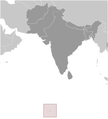
- archipelago in the Indian Ocean, south of India, about halfway between Africa and Indonesia
- Area
- 60 sq km
- Climate
- tropical marine; hot, humid, moderated by trade winds
- Terrain
- flat and low coral atolls (most areas do not exceed 2 m, or 6.6 ft, in elevation); sits atop the submarine volcanic Chagos-Laccadive Ridge
- Natural resources
- coconuts, fish, sugarcane
- Coastline
- 698 km
- Natural hazards
- none; located outside routes of Indian Ocean cyclones
People & society
- Population
- no permanent inhabitants
Economy
- Economic overview
- small island territory economy; economic activity mainly on Diego Garcia with national military installations; recently settled disputes with Mauritius have increased oil exports; established marine reserve has limited commercial fishing
- Exports - partners
- Singapore 86%, Pakistan 8%, USA 1%, South Africa 1%, Czechia 1% (2023)
- Imports - partners
- Greece 52%, Singapore 38%, USA 4%, Panama 2%, UAE 2% (2023)
Government
- Capital
- administered from London; often regarded as being on Diego Garcia
- Constitution
- British Indian Ocean Territory (Constitution) Order 2004
- Executive branch
- King CHARLES III (since 8 September 2022)
Full reference data
Every field, by section, CIA World Factbook. Open a topic to expand it.