
Country exposure · OO
Southern Ocean
Oceans
What Southern Ocean means for your money, the prices you pay, the tariffs in motion, and where U.S. policy could change both.
U.S. exposure
Minimal direct economic exposure
Southern Ocean is not a significant U.S. goods-trade partner and has no tracked tariff actions. Policy changes here are unlikely to reach American prices directly.
Reference
The country itself
Oceans · Geography, people, economy, and government, public-domain data from the CIA World Factbook.
A large body of recent oceanographic research has shown that the Antarctic Circumpolar Current (ACC), an ocean current that flows from west to east around Antarctica, plays a crucial role in global ocean circulation. The region where the cold waters of the ACC meet and mingle with the warmer waters of the north defines a distinct border -- the Antarctic Convergence -- which fluctuates with the seasons but encompasses a discrete body of water and a unique ecologic region. The Convergence concentrates nutrients, which promotes marine plant life, which in turn allows for a greater abundance of animal life. In 2000, the International Hydrographic Organization delimited the waters within the Convergence as a fifth world ocean basin -- the Southern Ocean -- by combining the southern portions of the Atlantic Ocean, Indian Ocean, and Pacific Ocean. The Southern Ocean extends from the coast of Antarctica north to 60 degrees south latitude, which coincides with the Antarctic Treaty region and which approximates the extent of the Antarctic Convergence. As such, the Southern Ocean is now the fourth largest of the world's five ocean basins (after the Pacific Ocean, Atlantic Ocean, and Indian Ocean). It should be noted that inclusion of the Southern Ocean does not imply US Government recognition of this feature as one of the world's primary ocean basins.
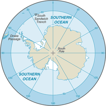
Geography
- Location
- body of water between 60 degrees south latitude and Antarctica
- Area
- 21.96 million sq km
- Climate
- sea temperatures vary from about 10 degrees Celsius to -2 degrees Celsius; cyclonic storms travel eastward around the continent and frequently are intense because of the temperature contrast between ice and open ocean; the ocean area from about latitude 40 south to the Antarctic Circle has the strongest average winds found anywhere on Earth; in winter the ocean freezes outward to 65 degrees south latitude in the Pacific sector and 55 degrees south latitude in the Atlantic sector, lowering surface temperatures well below 0 degrees Celsius; at some coastal points intense persistent drainage winds from the interior keep the shoreline ice-free throughout the winter
- Natural resources
- probable large oil and gas fields on the continental margin; manganese nodules, possible placer deposits, sand and gravel, fresh water as icebergs; krill, fish
- Coastline
- 17,968 km
- Natural hazards
- huge icebergs with drafts up to several hundred meters; smaller bergs and iceberg fragments; sea ice (generally 0.5 to 1 m thick) with sometimes dynamic short-term variations and with large annual and interannual variations; deep continental shelf floored by glacial deposits varying widely over short distances; high winds and large waves much of the year; ship icing, especially May-October; most of region is remote from sources of search and rescue
Full reference data
Every field, by section, CIA World Factbook. Open a topic to expand it.