Country exposure · VQ
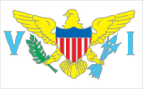
Virgin Islands
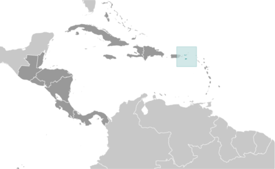
Central America N Caribbean · Charlotte Amalie · unincorporated organized territory of the US with local self-government; republican form of territorial government with separate executive, legislative, and judicial branches
What Virgin Islands means for your money, the prices you pay, the tariffs in motion, and where U.S. policy could change both.
104K
Population
$4.7B
GDP
U.S. exposure
Minimal direct economic exposure
Virgin Islands is not a significant U.S. goods-trade partner and has no tracked tariff actions. Policy changes here are unlikely to reach American prices directly.
Reference
The country itself
Central America N Caribbean · Geography, people, economy, and government, public-domain data from the CIA World Factbook.
The Danes secured control over the southern Virgin Islands of Saint Thomas, Saint John, and Saint Croix during the 17th and early 18th centuries. Sugarcane, produced by African slave labor, drove the islands' economy during the 18th and early 19th centuries. In 1917, the US purchased the Danish holdings, which had been in economic decline since the abolition of slavery in 1848. In 2017, Hurricane Irma passed over the northern Virgin Islands of Saint Thomas and Saint John and inflicted severe damage to structures, roads, the airport on Saint Thomas, communications, and electricity. Less than two weeks later, Hurricane Maria passed over the island of Saint Croix in the southern Virgin Islands, inflicting considerable damage with heavy winds and flooding rains.
Geography
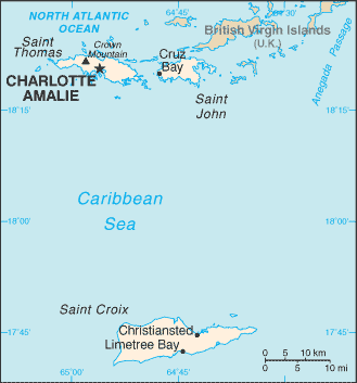
- Location
- Caribbean, islands between the Caribbean Sea and the North Atlantic Ocean, east of Puerto Rico
- Area
- 1,910 sq km
- Climate
- subtropical, tempered by easterly trade winds, relatively low humidity, little seasonal temperature variation; rainy season September to November
- Terrain
- mostly hilly to rugged and mountainous with little flat land
- Natural resources
- pleasant climate, beaches foster tourism
- Coastline
- 188 km
- Natural hazards
- several hurricanes in recent years; frequent and severe droughts and floods; occasional earthquakes
People & society
- Population
- 103,792 (2025 est.)
- Nationality
- Virgin Islander(s) (US citizens)
- Ethnic groups
- African-American or African descent 71.4%, White 13.3%, Indigenous 0.4%, Native Hawaiian and other Pacific Islander 0.1%, other 6.3%, mixed 7.5% (2020 est.)
- Languages
- English 71.6%, Spanish or Spanish Creole 17.2%, French or French Creole 8.6%, other 2.5% (2010 est.)
- Religions
- Protestant 65.5%, Roman Catholic 27.1%, other Christians 2.2%, other 1.5%, none 3.7% (2010 est.)
- Median age
- 43.4 years (2025 est.)
- Life expectancy at birth
- 80.7 years (2024 est.)
Economy
- Economic overview
- high-income, tourism-based American territorial economy; severe COVID-19 economic disruptions; major rum distillery; high public debt; sluggish reopening of large oil refinery; environmentally susceptible to hurricanes; many informal industries
- Industries
- tourism, watch assembly, rum distilling, construction, pharmaceuticals, electronics
- Agricultural products
- fruit, vegetables, sorghum; Senepol cattle
- Exports - partners
- Haiti 14%, Guadeloupe 7%, Malaysia 7%, Martinique 7%, Barbados 7%, British Virgin Islands 5% (2019)
- Imports - partners
- India 18%, Algeria 14%, South Korea 9%, Argentina 9%, Sweden 7%, Brazil 5% (2019)
Government
- Government type
- unincorporated organized territory of the US with local self-government; republican form of territorial government with separate executive, legislative, and judicial branches
- Capital
- Charlotte Amalie
- Independence
- none (territory of the US)
- Constitution
- 22 July 1954 - the Revised Organic Act of the Virgin Islands functions as a constitution for this US territory
- Executive branch
- President Donald J. TRUMP (since 20 January 2025)
- Legislative branch
- note: the Virgin Islands delegate to the US House of Representatives can vote when serving on a committee and when the House meets as the Committee of the Whole House, but not when legislation is submitted for a “full floor” House vote
Full reference data
Every field, by section, CIA World Factbook. Open a topic to expand it.
Introduction
Travel Facts
Please visit the following links to find further information about your desired destination.
CDC - To learn what vaccines and health precautions to take while visiting your destination.
US State Dept Travel Information - Overall information about foreign travel for US citizens.
To obtain an international driving permit (IDP). Only two organizations in the US issue IDPs: American Automobile Association (AAA) and American Automobile Touring Alliance (AATA)
How to get help in an emergency? Contact the nearest US embassy or consulate, or call one of these numbers: from the US or Canada - 1-888-407-4747 or from Overseas - +1 202-501-4444
Page last updated: Tuesday, July 02, 2024