Country exposure · WQ

Wake Island
Australia Oceania
What Wake Island means for your money, the prices you pay, the tariffs in motion, and where U.S. policy could change both.
U.S. exposure
Minimal direct economic exposure
Wake Island is not a significant U.S. goods-trade partner and has no tracked tariff actions. Policy changes here are unlikely to reach American prices directly.
Reference
The country itself
Australia Oceania · Geography, people, economy, and government, public-domain data from the CIA World Factbook.
Early Micronesian and Polynesian settlers probably visited Wake Island, and oral legends tell of periodic voyages to the islands by people from the Marshall Islands. Wake Island was uninhabited when Spanish explorer Alvaro de Mendana de NEYRA became the first European to see it in 1568 and still had no inhabitants when English captain Samuel WAKE sailed by it in 1796. The United States Exploring Expedition visited the island in 1841, and the US annexed it in 1899 to use as a cable and refueling station for its newly acquired Pacific territories of Hawaii, the Philippines, and Guam. In the 1930s, Pan American Airways built facilities on Wake Island so that it could be used as a stopover for flights from the US to China. In 1941, the US began to install military assets on Wake Island, and Japan then captured the island and held it until the end of World War II. In 1946, commercial airlines resumed using Wake Island as a refueling stop. In 1973, the Marshall Islands claimed Wake Island, based on the oral legends, although the US has not recognized these claims. In 1974, the US military took exclusive control of the island’s airstrip and restricted visitors. In 1978, Bikini Islanders from the Marshall Islands, who were evacuated in the 1950s and 1960s because of US nuclear tests, considered rehoming on Wake Island, but the US military rejected that plan. Since the 1970s, the island has been important for missile defense testing. In 2009, Wake Island was included in the Pacific Remote Islands Marine National Monument.
Geography
- Location
- Oceania, atoll in the North Pacific Ocean, about two-thirds of the way from Hawaii to the Northern Mariana Islands
- Area
- 7 sq km
- Climate
- tropical
- Terrain
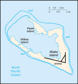
- atoll of three low coral islands, Peale, Wake, and Wilkes, built up on an underwater volcano; central lagoon is former crater, islands are part of the rim
- Natural resources
- none
- Coastline
- 19.3 km
- Natural hazards
- subject to occasional typhoons
People & society
- Population
- no permanent inhabitants
Government
- Independence
- none (territory of the US)
Full reference data
Every field, by section, CIA World Factbook. Open a topic to expand it.