
Country exposure · ZH
Atlantic Ocean
Oceans
What Atlantic Ocean means for your money, the prices you pay, the tariffs in motion, and where U.S. policy could change both.
U.S. exposure
Minimal direct economic exposure
Atlantic Ocean is not a significant U.S. goods-trade partner and has no tracked tariff actions. Policy changes here are unlikely to reach American prices directly.
Reference
The country itself
Oceans · Geography, people, economy, and government, public-domain data from the CIA World Factbook.
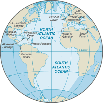
The Atlantic Ocean is the second largest of the world's five ocean basins (after the Pacific Ocean, but larger than the Indian Ocean, Southern Ocean, and Arctic Ocean). The Kiel Canal (Germany), Oresund (Denmark-Sweden), Bosporus (Turkey), Strait of Gibraltar (Morocco-Spain), and the Saint Lawrence Seaway (Canada-US) are important strategic access waterways. The decision by the International Hydrographic Organization in the spring of 2000 to delimit a fifth world ocean basin, the Southern Ocean, removed the portion of the Atlantic Ocean south of 60 degrees south latitude. For convenience and because of its immense size, the Atlantic Ocean is often divided at the Equator and designated as the North Atlantic Ocean and the South Atlantic Ocean.
Geography
- Location
- body of water between Africa, Europe, the Arctic Ocean, the Americas, and the Southern Ocean
- Area
- 85.133 million sq km
- Climate
- tropical cyclones (hurricanes) develop off the coast of Africa near Cabo Verde and move westward into the Caribbean Sea; hurricanes can occur from May to December but are most frequent from August to November
- Natural resources
- oil and gas fields, fish, marine mammals (seals and whales), sand and gravel aggregates, placer deposits, polymetallic nodules, precious stones
- Coastline
- 111,866 km
- Natural hazards
- icebergs common in Davis Strait, Denmark Strait, and the northwestern Atlantic Ocean from February to August and have been spotted as far south as Bermuda and the Madeira Islands; ships subject to superstructure icing in extreme northern Atlantic from October to May; persistent fog can be a maritime hazard from May to September; hurricanes (May to December)
Full reference data
Every field, by section, CIA World Factbook. Open a topic to expand it.