
Country exposure · ZN
Pacific Ocean
Oceans
What Pacific Ocean means for your money, the prices you pay, the tariffs in motion, and where U.S. policy could change both.
U.S. exposure
Minimal direct economic exposure
Pacific Ocean is not a significant U.S. goods-trade partner and has no tracked tariff actions. Policy changes here are unlikely to reach American prices directly.
Reference
The country itself
Oceans · Geography, people, economy, and government, public-domain data from the CIA World Factbook.
The Pacific Ocean is the largest of the world's five ocean basins (followed by the Atlantic Ocean, Indian Ocean, Southern Ocean, and Arctic Ocean). Strategically important access waterways include the La Perouse, Tsugaru, Tsushima, Taiwan, Singapore, and Torres Straits. The International Hydrographic Organization decision in 2000 to delimit a fifth world ocean basin, the Southern Ocean, removed the portion of the Pacific Ocean south of 60 degrees south. For convenience and because of its immense size, the Pacific Ocean is often divided at the Equator and designated as the North Pacific Ocean and the South Pacific Ocean.
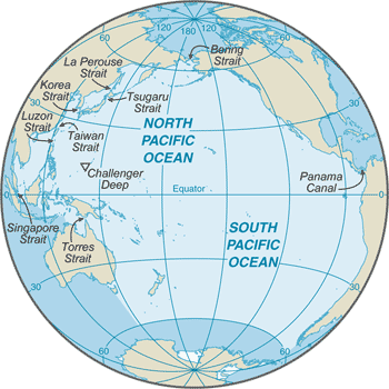
Geography
- Location
- body of water between the Southern Ocean, Asia, Australia, and the Western Hemisphere
- Area
- 168.723 million sq km
- Climate
- planetary air pressure systems and resultant wind patterns exhibit remarkable uniformity in the south and east; trade winds and westerly winds are well-developed patterns, modified by seasonal fluctuations; tropical cyclones (hurricanes) may form south of Mexico from June to October and affect Mexico and Central America; continental influences cause climatic uniformity to be much less pronounced in the eastern and western regions at the same latitude in the North Pacific Ocean; the western Pacific is monsoonal - a rainy season occurs during the summer months, when moisture-laden winds blow from the ocean over the land, and a dry season during the winter months, when dry winds blow from the Asian landmass back to the ocean; tropical cyclones (typhoons) may strike southeast and east Asia from May to December
- Natural resources
- oil and gas fields, polymetallic nodules, sand and gravel aggregates, placer deposits, fish
- Coastline
- 135,663 km
- Natural hazards
- surrounded by a zone of violent volcanic and earthquake activity sometimes referred to as the "Pacific Ring of Fire"; up to 90% of the world's earthquakes and some 75% of the world's volcanoes occur within the Ring of Fire; 80% of tsunamis, caused by volcanic or seismic events, occur within the "Pacific Ring of Fire"; subject to tropical cyclones (typhoons) in southeast and east Asia from May to December (most frequent from July to October); tropical cyclones (hurricanes) may form south of Mexico and strike Central America and Mexico from June to October (most common in August and September); cyclical El Niño/La Niña phenomenon occurs in the equatorial Pacific, influencing weather in the Western Hemisphere and the western Pacific; ships subject to superstructure icing in extreme north from October to May; persistent fog in the northern Pacific can be a maritime hazard from June to December
Full reference data
Every field, by section, CIA World Factbook. Open a topic to expand it.